Using the assistant
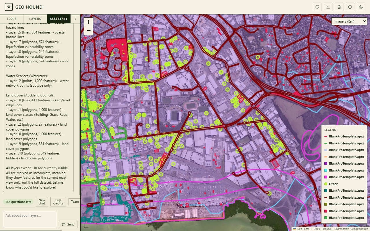
The assistant is a chat that drives the workbench for you. You describe what you want in plain English and it carries out the GIS operations, using the same tools the interface exposes, plus a few it does not.
It is for people who know what they want to know but not which button produces it.
Where it lives
Open the workbench and the Assistant tab is already there in the rail. It is the tab that is open when the workbench loads.
The first time, you get a consent notice explaining what gets sent. Click Got it, enable chat and it stays enabled.
Once you have asked something, a pill appears showing how many questions you have left, such as 7 questions left. That number is your remaining free questions plus any credits you have bought, added together. Hover it for the breakdown.
The prompt cookbook
The assistant has 26 tools. Rather than list them, here is what people actually type.
Finding out what you have
- "What layers do I have?"
- "Search my saved services for anything with parcels in it."
- "What fields does the flood zones layer have?"
- "How many features are in the wells layer?"
Asking questions of the data
- "Which suburb has the most building consents?"
- "How many parcels are bigger than two hectares?"
- "Show me the average depth of the wells."
- "List the ten largest polygons by area."
Styling and labelling
- "Make the flood zones orange and label them by name."
- "Colour the parcels by zoning."
- "Symbolize the wells by depth."
- "Turn the labels off."
- "Add a satellite basemap and zoom to my selection."
Analysis
- "Buffer the wells by 500 metres and tell me how many parcels fall inside."
- "Join the soil types onto my imported paddock boundaries."
- "How far is each school from the nearest fire station?"
- "Clip the vegetation layer to my property boundary."
- "Give me the centroid of each parcel."
- "Add a hectares column calculated from the area."
Selection and export
- "Select everything inside this polygon and export it as a shapefile."
- "Select the parcels that intersect the flood zone."
- "Save that selection as a layer."
- "Export the result as XLSX."
Chaining
The useful trick is that results feed into the next question:
- "Buffer the streams by 20 metres."
- "Now select the parcels that intersect that buffer."
- "Save those as a layer and colour them red."
- "Export it as a shapefile."
That whole sequence is four questions, so four credits, regardless of how many operations it triggers.
Things only the assistant can do
Two capabilities have no buttons in the workbench and are reachable only by asking:
- Overlay: clipping a layer to a polygon, or erasing the part inside one.
- The field calculator: adding, setting, renaming, or deleting a column, including calculating one from an expression.
It can also transform layers in ways the interface does not offer: centroids, bounding boxes, dissolve, simplify, and chopping lines into chunks.
Field calculations affect only your local copy of the data. The service you got it from is never modified. Geo Hound never writes to anybody's service.
What leaves your browser
This is the one part of Geo Hound that sends your data anywhere, so it is worth being precise.
Sent with every question: a summary of your workbench. Layer names, geometry types
as words (Polygon, not coordinates), feature counts, field names and their types, and
how many features you have selected.
Sent as the assistant works: the results of its tool steps, tightly capped. At most 20 attribute rows from a query, at most 10 sample values per field when it reads a schema, every value truncated at 200 characters, and about 8 KB per result.
Never sent: geometry, and whole datasets. The tools run in your browser against the live map; only their summarised results go back to the model.
The route is: your browser, to our server, to OpenRouter, which routes it on to a third-party model provider. Your identifier is not passed to OpenRouter.
Your conversations are not stored on our servers. We count messages and tokens for billing, and that is all. Zero data retention is enabled on our OpenRouter account. The transcript lives in your browser's memory only, and New chat or New session wipes it.
The full picture is in the privacy policy.
How credits are spent
- 1 credit is 1 question. You are charged when you send it.
- Tool steps are free. A question that takes fifteen operations costs one credit.
- Free questions go first. Your monthly free allowance is used before any credits you have bought.
- Stopping does not refund. Press Stop part way through a reply and the credit is still spent, because it was spent when you asked.
- Failures do refund. If our provider is unreachable or errors before replying, the credit is returned automatically.
Everyone gets up to 10 free questions per calendar month, resetting at the start of the month. It is a ceiling rather than a promise: free questions are also pooled per network address to stop abuse, so several people on one office connection may each get fewer. Credits are not affected by that.
There is a five-second minimum between questions. Ask faster and you get asked to wait.
Buying credits
Click Buy credits in the assistant, or wait until you hit zero and the panel opens itself. Three packs: 250 for $10, 550 for $20, 1,200 for $40.
Payment opens in a new tab and is handled by Stripe. Credits appear on your balance after checkout, and they never expire. See pricing for the full picture.
Your balance updates on your next question. There is no refresh button.
Restoring credits on a new machine
Your credits sit against an identifier your browser generated, so a new computer or a fresh install starts empty. Your purchase email is the anchor that moves them.
- Open the workbench chat and click Buy credits, then Restore purchases.
- Enter the email you used at checkout and click Send code.
- Check your email for a six-digit code. It expires in ten minutes.
- Enter it and click Restore. Your balance moves across.
You get five attempts per code and can request three codes an hour. The message is the same whether or not that email has purchases, which is deliberate: it stops anyone fishing for who has bought.
Restoring moves the balance rather than copying it.
If you bought credits and they never arrived, this is also the fix: a purchase that could not be matched to your install is waiting under your email.
What it is not
The assistant is a tool that runs GIS operations. It can misread a question or pick the wrong field, particularly when column names are cryptic. Look at the result before you rely on it. It is not a surveyor, not a lawyer, and not a substitute for checking the data provider's terms.